 The whole Miri town was filled with derricks and rigs 50-60 years ago, in the 1920s, 1930s and 1940s up until 1970s.
 Miri Miri! Every time I am in Miri, I'm here for work or for holiday. This time, it 's a combination of both. For work and fun. Who would have thought it is possible, except for geologists. haha!
Visiting the outcrop in Miri, is like getting to know every inch of this little town. To study what is beneath our feet, and what happened millions and millions of years ago.
After visiting Bintulu, Niah, and now Miri, can I believe that this whole Borneo island was submerged under the ocean a long, long time ago? Yes. I just couldn't believe it until the we examined everything under our noses. Yet, so much vegetation has taken place. The folding of the structures, compression and expansion of the moving plates of Borneo and Papua New Guinea, has changed the look of this island tremendously.
Our Geologist friends can just come up with the story of the birth of Borneo Island in seconds. It's superb, isn't it? With just a small amount of scrutiny and time spent on analysis, one can discover much about the past, present and future.
And so, back to our story. At the Airport Road, in Miri, we learnt to identify fault from the top and side view.
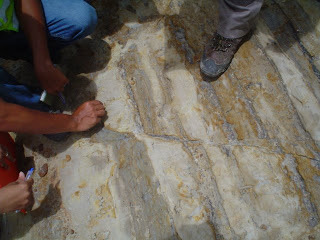
 These are trough bedding. How is it formed? By very strong waves, I guess. See! One should always pay attention during lessons.
I've been to Canada Hill, 3 times. Yet, I've never fully listened to the true story of how it came to be how it is today. And so, Pedro, made all of us sit down on the soft, green patch of grass at the back of the PETROSAINS museum in Miri, and told us of how Shell, Esso, and a few other oil companies were formed. He even brought along a big map to show us the geological structures of the Borneo island.
Amazingly, I've seen the oil accumulation in these areas quite a few times, and never once, has it occured to me that these accumulations face towards one direction. And because this area is highly faulted, and is highly sandwiched (i.e. laminated sands and shales), it forms a good hydrocarbon trap. Marine life used to be abundant here. Source rocks are from coals, and swampy areas, and coral reefs. The reservoirs are the channels from sandstones and carbonate fractures. Traps are the faults and muddy shales.
As with all outdoor excursions, we will always meet our insect friends. This time, I met the spider and the cicada. Of course I have never seen any cicadas before. Even if I did, I wouldn't have recognized it, because nobody pointed it out to me. Fortunately, this time, we have a very keen eyed professor whose eyes light up at the slightest strangest phenomena or living thing.
~~~~~~~~~~~~~~~~~~~~~~~~~~~~~~~~~~~~~~~~~~~~~~~~~~~~~~~~~~~~~~~~
Amazing Fact:
Today, the most common material used in the oil and gas industry is steel because it has high tensile strength.
Do you know which natural resource of ours on earth possesses similar properties and qualities of steel?
A hah! You got it! It's Bamboo! In the olden days, when China first started drilling for gas, they constructed everything out of bamboo! Even the rig and the drilling bit!
~~~~~~~~~~~~~~~~~~~~~~~~~~~~~~~~~~~~~~~~~~~~~~~~~~~~~~~~~~~~~~~~
~~~~~~~~~~~~~~~~~~~~~~~~~~~~~~~~~~~~~~~~~~~~~~~~~~~~~~~~~~~~~~~~
Amazing Fact:
Today, the most common material used in the oil and gas industry is steel because it has high tensile strength.
Do you know which natural resource of ours on earth possesses similar properties and qualities of steel?
A hah! You got it! It's Bamboo! In the olden days, when China first started drilling for gas, they constructed everything out of bamboo! Even the rig and the drilling bit!
~~~~~~~~~~~~~~~~~~~~~~~~~~~~~~~~~~~~~~~~~~~~~~~~~~~~~~~~~~~~~~~~


No comments:
Post a Comment