Saturday, March 14, 2009

Prospect of Travelling Through Sarawak

I have been pretty busy of late in the office. Taking up so many responsibilities, holding so many posts and roles has taken a toll on me. So, when my friend recently offered me a chance to replace her for a field trip in my beloved 2nd home of Sarawak, I happily nodded my head. I just couldn't wait to fly back to Miri, visit Bintulu and stop by all the famous 'tourist' destinations in the North of Sarawak.

I still feel a little guilty though. I have to complete so many jobs, attend various levels of meetings and still expect to perform at my job. Going for a field trip now is like stealing the forbidden fruit from the Garden of Eden. Yet, I miss Sarawak. The longing to go back to Borneo Island-My Second Home, tugs strongly at my heart. I need to go.

And so, in the midst of all the meetings and preparations, I went. A mixture of guilt, excitement, joy and happiness flooding through every inch of my veins.

Friday, March 13, 2009

Bintulu

Bintulu Airport reminds me very much of Miri Airport. Even the town is quite similar to Miri. Here, I feel at home. It's safe and it's near the beach. One can simply walk to the Bintulu Waterfront in the evening and start fishing, walking, or even fly a few kites all at the same time! How long has it been since I had the luxury of taking a stroll when the sun starts going down the hills?


Evening by the Bintulu Sea


Ever since I got to know my friends from Bintulu, I have always had a strong yearning to see how Bintulu looks like. It's near the sea, near the oil and gas downstream industry. Will it be polluted? Will it be like Lumut, when it was 20 years ago? with just a few shop houses, and few housing estates? My friends talk about Bintulu like it's a small town, not worth putting it on the map. There's no shopping malls, they say. Quiet, no clubs, no bars to hang out, no entertainment. That was about 5 years ago.


Parkcity Everly Hotel- Our Residence for 3 days

Today, the town is quite developed. I see many rising buildings especially shopping malls and new hotels. The town takes about 20 minutes to finish 'touring' by car, and that does not even include the industrial area.

Tanjung

In the evening, one can see several men and women in coloured coveralls riding on motorbikes, or in buses returning home after a long day's work. It is really a very nice town to live in.

Fishing-Favourite Pasttime at the Bintulu Waterfront

Landscape of Bintulu Waterfront


Thursday, March 12, 2009

Bintulu Outcrop

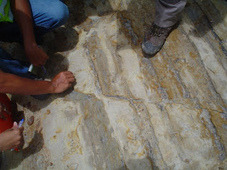
In Bintulu, we visited several Outcrops. Among them were the Tatau, Nyalau and Liang Formations, formed during the Paleocene, Pliocene and Miocene times.

What are outcrops, you may ask. Well, outcrops are uplifted structures, cut through by road builders. Just imagine a piece of layered cake. From the surface, you may think that it's brown throughout. But when you cut through it, you will see several colourful layers, thin layers, thick layers, all of different colours and composition. The earth is just like that as well. It does not contain sediments from a single period, nor single composition. It consists of several grains of different sizes and organic matter.Varying depositional environment will form different patterns in the outcrop when one cuts through it.

On the first day itself, I learnt how to identify the amount of organic matter present in any lithology. The blacker or darker it is, the higher the amount of organic matter. If we have white sand, means we don't have organisms living here. If we have very black sand, this indicates that there were lots of organic matter living here last time. This can be proved by the presence of burrows, forams, shells, fossilized crabs, etc. However, that may not be necessarily true all the time. Sometimes, the sand can be very black as well if it is coated with manganese.

So, if we 're looking for source rocks, we don't go looking for rivers upstream, where it's highly oxidized and the water is very clear. Source rocks are usually present downstream, where there's less energy, all the grains get to settle down, the water is calm, and there's potential for the survival of organic matter.

A stream is also divided into upstream and downstream. Grains from an upstream river are angular because they have been 'sharpened' by the high energy flow. Besides that, the grains are very coarse, and may even be classified as boulders. No specific arrangement for the grains upstream can be observed because the flow is rather turbulent. This leaves the grain no time to settle down. Before they even start resting at the bottom of the river bed, they are pushed hard and strong by the energy of the gushing waters. Downstream of a river, the sand grains are rounder, smaller and settle down in the river bed in a nice layer. Thin or thick, that depends on the water level, and surrounding environment.
Looking at the ripples, one can also determine the flow direction

So, how do we recognize whether these compacted sands or rock bodies are from the river, sea, beach or swamps? Besides looking at the grain size and the sorting arrangement, we also look at the fossils and composition present. It is quite often you will have stunning findings.


For instance, we saw roots burried in the formation in the miocene times... or clay that were formed during the pliocene times. Just imagine that. A storm came, a river passed through the region, an earthquake occured and the whole forest were burried under tonnes and tonnes of sands overnight. Wow.... I'm awed.

Black, Shiny Coal

After a long, long time, once these roots are burried under high pressure and high temperature, compacted by the hydrostatic pressure and the lithostatic pressure, these roots from millions and millions of trees become coal.


(Top View): You see these little grey marks on the rocks? They're burrows made by crabs!


Sometimes, we also spot burrows which used to be houses for the little crabs. In some of these burrows, the pellets are still very well preserved even after millions and millions of years!
(cross sectional view): These are burrows in the rocks

At one of our stops, we saw a 'hole' in the sky made by the fluffy white clouds.
~~~~~~~~~~~~~~~~~~~~~~~~~~~~~~~~~~~~~~~~~~~~~~~~~~~~~~~~~~~~~~~~

Extra Notes about Sandstone:

Hieratus is a period of non-deposition. Another name for unconformity.

Pyrite or gold is formed under reduced oxygen environment. It is a product of the reaction between iron and sulfur. That is why in Sarawak, we have low H2S content. Under high sulfur conditions, iron reacts with sulfur to form pyrite.

Carbonates, on the other hand, contain high H2S. None of the minerals present are able to bond with Sulphur to form another mineral. Thus, sulphur content in carbonate rocks are often very high.

~~~~~~~~~~~~~~~~~~~~~~~~~~~~~~~~~~~~~~~~~~~~~~~~~~~~~~~~~~~~~~~~


Wednesday, March 11, 2009

Niah Quarry and Caves

Have you ever thought of looking for fish fossils or corals on top of a mountain? A hah! Never once in your life would you ever thought that this would be possible, did you? I for one certainly didn't think that it was. Until, I visited the quarry and caves in Niah, which originated from the carbonate depositional environment.

Niah Quarry: Look at the size of the Hill compared with the lorry

Pinnacles
(Don't have to climb Gunung Api to see this. haha! I can even see it cut into half!)


At the quarry, we were trained to open our eyes as wide as possible, using the microscope to look through every rock, looking for fossils and minerals. Hmm.. since I didn't really pay attention to what the instructor said under the burning, hot sun, my memory fails to enlighten me even though I am squeezing my brain juices dry.


Seashells embedded in rocks. Dark Grey:Mud, Light grey: Fossils


So, when we did look hard enough, and train our eyes to be really sharp, we spotted several rocks with corals inside it! The more we scanned through the area, the more surprise we got! We spotted several rocks with calcite or pyrite minerals growing inside the rocks! They were white, translucent and very very light! Geez!

Calcite Minerals Formed in Carbonate Rocks

Guess what? When we poured Hydrochloric acid on this carbonate rocks, they fizzled like the foams on the sea.


Fizzling Carbonate Rocks (Reacts with Hycrochloric Acid)

Types of Carbonate Rocks (According to increasing Mud composition, from right)
Whackedstone (More than 8% Granules), Grainstone, Mudstone (Less than 8% Granules)


Walking Under the Bright Hot Sun


Though we had to walk under high heat on that bright, sunny day, we learnt a lot. We even got to climb to the viewing point at the hill with the Telekom Tower, and look at the Reef from afar. If all of this Niah were under water, it would have been equivalent to Australia's Great Barrier Reef. ( I guess).

Look at all these Carbonate Reefs. The whole dark green stretch of Carbonate Rocks which used to house Corals and abundant marine life.
What a long and big platform! Amazing, isn't it?

~~~~~~~~~~~~~~~~~~~~~~~~~~~~~~~~~~~~~~~~~~~~~~~~~~~~~~~~~~~~~~~~

Facts about Carbonate Rocks
Calcium carbonate rocks are formed from corals and marine life, animals and plants under the sea. They are plant matter, need lots of light to survive. Corals are only able to survive in warm weather. That is why there are lots of carbonate reefs in the Middle East. However, there is an exception. In some parts of the world, white corals do exist in deep marine environment. They are formed from algae. Because there is no light, the plants are unable to conduct photosyntesis, so, its white instead of being multi-coloured.


Upon first look, one might think that the whole stretch of carbonate reef was formed at the same time. However, that is a misconception. In actual fact, when we scrutinize this outcrop, we will notice the sigmoidal patterns on the rocks (Figure below). This tells us that the reefs were formed at different periods of time.


Do you know how caves are formed? Carbonate rocks are very brittle structures which contain lots of calcium. When subject to forces, they break and fracture easily, forming good reservoirs for hydrocarbon. So, when a pore or a fracture is present in the rock, it will form a natural flow path. Water from the ocean will flow through it, bringing along sand and finer materials which will erode and 'knocks' against the walls of the hole. After a long time and a repetition of the above process, the hole gets bigger and bigger, until finally, a horizontal hole is formed from the horizontal flow.

When the earth moves, and the plate on which the carbonate reef is seated upon is compressed, our reefs will rise higher and higher, until it is elevated above sea level. Soon, just a small stream of river will flow through that hole. As the plate gets lifted up higher, the cave is elevated as well. That horizontal hole is what we call "caves".

When we travel along Ipoh roads and the Batu Caves, we will notice that there are several caves which are located at different heights on the same limestone hill. What I never notice is that these caves are often 'seated' one upon the other. It looks like a series of caves. How can that be?

Well, when the first cave is formed, the carbonate rock is uplifted as well. After some time, more and more caves will be formed and we have then a very complicated network of cave system. One thing we must remember though. The oldest caves are at the top of the hill and the youngest caves are at the bottom of the hill. This is probably because the water near the surface is more turbulent than the current at the seabed. So, the chances of being 'roughen up' is higher at the top.

And that, is the story of the formation of Niah and Mulu Caves and limestone hills.

~~~~~~~~~~~~~~~~~~~~~~~~~~~~~~~~~~~~~~~~~~~~~~~~~~~~~~~~~~~~~~~~


Tuesday, March 10, 2009

Bungai Beach

The trip to the beach was the most wonderful one of all. Here, we learnt from Pedro, our instructor, Professor Lee, famed in the G&G arena, and Than Wi, our senior geologist. The weather at the beach was cool, windy, practical and hands on. We got to witness the forming of tidal flats first hand from Mother Nature itself.

Laminated Sand, shale , sand shale (Tidal flats), sandwich of sand and shales , mud and sand. The sand was cut by a Parang.

Notice how these rocks are alligned in a straight line, at an angle towards the coming waves

Embedded Forams (lala), (Sliced in half) . Imagine all these lala burried alive! What a loss of livelihood for those who live by the sea, and a loss of delicious seafood for seafood lovers like me.

Have you ever seen a lagoon and a sandbar? Well, I haven't. It was a defining moment for me. Never have I imagined that such a depositional environment would occur. Perhaps this exists only at the coastlines of Sarawak. In Peninsular Malaysia, I've never seen it. Do let me know if you've seen one in Semenanjung Malaysia. I'll drive all the way htere just to snap a picture of it.
Asrul standing on the sandbar, in front of him is the lagoon.

Did you know the foams on the sea you see sometimes consist of little algae micro-organisms? A hah! That's true! I learnt that on my visit to the beach too!
Algae which will form corals later on (and become our source of hydrocarbon)

Raindrops, seashells and sand. Perfect combination.
Notice how the shells are facing down? It's for stability.

Our instructor, Pedro, taught us using his Parang, a long sharp, wielding knife. He drew a square on the beach, focusing on the burrows and crab pellets which was formed just a few minutes before we arrived. "These can be preserved! You don't believe me? Wait 'til I bring you to Miri!" he says.

I doubted his words. Only later on, when I saw proof in front of my eyes, that I believed him through and through.

Big Burrow by Big Crab, in the Holocene Period (Present)

"What are these? How can this 'pattern' possibly be made? What is it made of?" asks Pedro, our passionate teacher, who is so eager to pass on everything he knows to us that he rushes through every lesson, speaking like a walking encyclopedia. His students, equally eager, scribble down everything he says and clings onto his every word. Never a moment doubting, always trusting.

We think, but we can't relate it to our everyday life. Until Idzwan, one of the brilliant ones amongst us, suggests, "Raindrops!"

"You're right!" exclaims Pedro! "Excellent!"

Raindrops on the Sand

These rocks will never be formed at an angle perpendicular to the direction of the waves. When the waves hit the coastline, some of its energy is transferred and transformed and dissipated to the left and right at a particular angle. After some time, the rocks form along a certain pattern.
Mathematics in Nature: Rocks deposited at an angle, in a parallel line

~~~~~~~~~~~~~~~~~~~~~~~~~~~~~~~~~~~~~~~~~~~~~~~~~~~~~~~~~~~~~~~

Relationship between water level and the Earth movement:

The way water circles the earth is like hoola-hoop on the Hawaiian dancers' waist. The earth is always tilting at different angles, and its axis changes from time to time. Water moves around the earth in elliptically and is dependent upon the following factors:
a) Gravity
b) Position of the planet
c) Magnetic field

From sequence stratigraphy, we are able to determine the climate and changes of sea level millions and billions of years ago. Why would we want to determine the sea level millions of years ago? Apparently, usually, high frequency events will contain hydrocarbon.

If one is dilligent enough, and decides to plot the shape of hydrocarbon accumulation in Sarawak, one will discover that all of it faces towards one direction and the shape is almost identical. This is due to the plate movement and highly fractured formation.

~~~~~~~~~~~~~~~~~~~~~~~~~~~~~~~~~~~~~~~~~~~~~~~~~~~~~~~~~~~~~~~~


Monday, March 09, 2009

Miri, Here I am again!

The whole Miri town was filled with derricks and rigs 50-60 years ago, in the 1920s, 1930s and 1940s up until 1970s.


Miri Miri! Every time I am in Miri, I'm here for work or for holiday. This time, it 's a combination of both. For work and fun. Who would have thought it is possible, except for geologists. haha!

Visiting the outcrop in Miri, is like getting to know every inch of this little town. To study what is beneath our feet, and what happened millions and millions of years ago.

After visiting Bintulu, Niah, and now Miri, can I believe that this whole Borneo island was submerged under the ocean a long, long time ago? Yes. I just couldn't believe it until the we examined everything under our noses. Yet, so much vegetation has taken place. The folding of the structures, compression and expansion of the moving plates of Borneo and Papua New Guinea, has changed the look of this island tremendously.

Our Geologist friends can just come up with the story of the birth of Borneo Island in seconds. It's superb, isn't it? With just a small amount of scrutiny and time spent on analysis, one can discover much about the past, present and future.

And so, back to our story. At the Airport Road, in Miri, we learnt to identify fault from the top and side view.

This is a normal fault. Why? Because there is displacement of Sand. As you can see, the thickness of some sands are thicker on the other side of the fault.

These are trough bedding. How is it formed? By very strong waves, I guess. See! One should always pay attention during lessons.


Cross Bedding: Waves from different directions, indication of high energy environment.

Big , long horizontal burrows: Indication of low energy environment.

You see it now? Preserved Crab Pellets. "Now you believe me?" asks Pedro.


A rare jewel: 3-Dimensional Burrow.

I've been to Canada Hill, 3 times. Yet, I've never fully listened to the true story of how it came to be how it is today. And so, Pedro, made all of us sit down on the soft, green patch of grass at the back of the PETROSAINS museum in Miri, and told us of how Shell, Esso, and a few other oil companies were formed. He even brought along a big map to show us the geological structures of the Borneo island.

Amazingly, I've seen the oil accumulation in these areas quite a few times, and never once, has it occured to me that these accumulations face towards one direction. And because this area is highly faulted, and is highly sandwiched (i.e. laminated sands and shales), it forms a good hydrocarbon trap. Marine life used to be abundant here. Source rocks are from coals, and swampy areas, and coral reefs. The reservoirs are the channels from sandstones and carbonate fractures. Traps are the faults and muddy shales.

As with all outdoor excursions, we will always meet our insect friends. This time, I met the spider and the cicada. Of course I have never seen any cicadas before. Even if I did, I wouldn't have recognized it, because nobody pointed it out to me. Fortunately, this time, we have a very keen eyed professor whose eyes light up at the slightest strangest phenomena or living thing.


Rare Cicada on top of Canada Hill

The Wild Yellow Spider

~~~~~~~~~~~~~~~~~~~~~~~~~~~~~~~~~~~~~~~~~~~~~~~~~~~~~~~~~~~~~~~~
Amazing Fact:

Today, the most common material used in the oil and gas industry is steel because it has high tensile strength.

Do you know which natural resource of ours on earth possesses similar properties and qualities of steel?

A hah! You got it! It's Bamboo! In the olden days, when China first started drilling for gas, they constructed everything out of bamboo! Even the rig and the drilling bit!

~~~~~~~~~~~~~~~~~~~~~~~~~~~~~~~~~~~~~~~~~~~~~~~~~~~~~~~~~~~~~~~~

Sunday, March 08, 2009

After Thoughts

I thoroughly enjoyed this trip through and through. Even though we had to walk up the hills, deep into the jungle and dark caves, stepping onto the local residents' dragonfruit and pineapple plantations, we got to witness locals climbing long poles to harvest the birds' nest, carrying big, heavy bags of guano. At the end of the day, it was well worth it. Ultimately, I had increased my vocabulary, knowledge and my range of topics for my Travelog! haha!

Dragon Fruit Trees - All the way from Bintulu to Miri


Rain Drop Collector-Dragon Fruit Tree Leaves

Will I join this kind of field trip again? Definitely.

Next on my travel plan: Mount KK, White Water Rafting, Diving and perhaps jungle trekking in my own backyard.
~~~~~~~~~~~~~~~~~~~~~~~~~~~~~~~~~~~~~~~~~~~~~~~~~~~~~~~~~~~~~~~~
As we move on in life, we often take many things for granted. For instance, the affection of our loved ones, our calm lives or the very simple fact that we have jobs. We never appreciate them until we lose them. Sometimes, we don't even notice how important they are in our lives until it affects our lives tremendously.

Like the puddle of water on the road. Nobody notices it until the driver drives into it, gets stuck, and realizes it's actually masking a very deep hole!

Or, the roadside pebble. Nobody will look at it until a passing vehicle accidentally hits it and propels it towards the next oncoming car, and cracks its windscreen.

After putting on the hat of a petroleum geologist for a week, I learned to scrutinize everything under my nose. There are always clues to minor and catastrophic events. If only we pay more attention to the little things in life, we will be able to know what happened in the past, what's happening now and possibly predict events in the nearest future.

Why do I think is it important to observe, analyze and hypothesize? Well, if we know what's going to happen, at least we will be fully equipped when the waves hit our shore. It's not because we can be the ones who says the cheeky phrase, " I told you so!".
~~~~~~~~~~~~~~~~~~~~~~~~~~~~~~~~~~~~~~~~~~~~~~~~~~~~~~~~~~~~~~~~